ONLY a few weeks ago Jersey was sweltering in its second-hottest June on record…
But July has put a dampener on the summer – and the bad news for anyone with holiday plans in the UK or much of France is that the very average weather looks set to stay.
While swathes of southern Europe bake in some of the most extreme heat the continent has ever recorded, more northern areas have been stuck in cool, wet and generally miserable conditions.
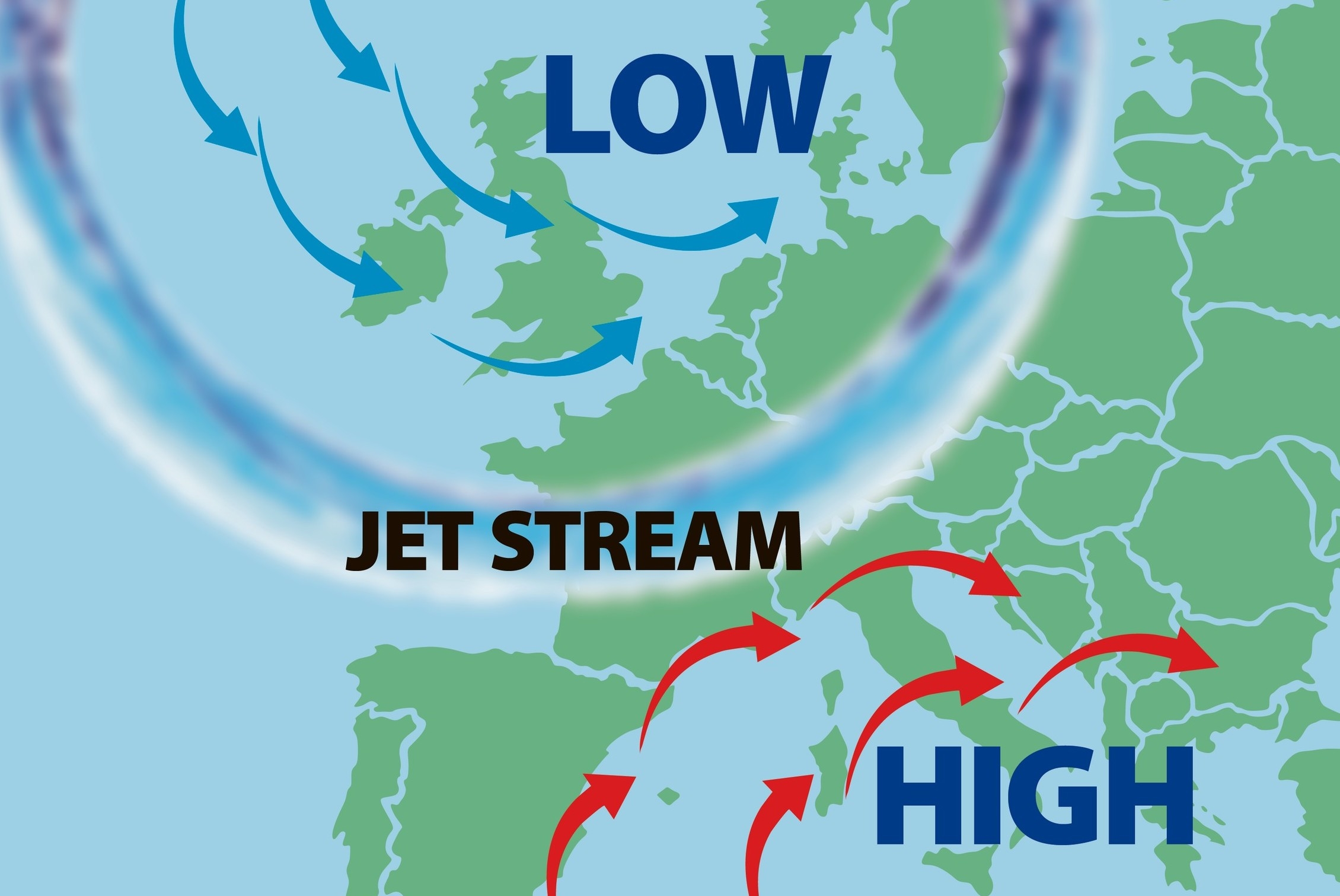
The culprit is the jet stream – a band of winds high up in the atmosphere which drives areas of low pressure across the Atlantic.
It is currently in a meandering pattern, and Jersey and the UK are stuck in a trough to its northern edge – essentially the cool side where low pressures form.
The provisional average daily maximum temperature recorded this July is 21.7°C – slightly below the long-term average of 22°C – and 33.6mm of rain has already been registered, close to the long-term average for the whole of the month (45.3mm).
And, forecasters say, there is no hint that the conditions are going to improve any time soon.
This month’s weather is in stark contrast to last summer’s heatwave, which saw the Island record its hottest ever day on 18 July, with a temperature of 37.9°C.
Matt Winter, senior forecaster at Jersey Met, said: ‘The jet stream is currently meandering across the northern hemisphere, so there are bulges pushing north, and that is where you get high pressure, and troughs pointing south, which is where you get low pressure.
‘The Channel Islands, much of France and the British Isles are on the northern side of the jet [in a trough] and that doesn’t look like it will change in the next ten days to two weeks.
‘So temperatures are expected to be average or slightly below average and there are no particular signs of any long periods of settled weather.’
Meanwhile, in parts of southern Europe, where temperatures have reached well over 40°C, people have been told to stay indoors amid concerns that the extreme heat could cause a spike in deaths.
Parts of the USA and China have also been gripped by intense heatwaves during recent weeks.
According to Chinese state media, a remote township in the country’s arid northwest registered a temperature of 52°C on Sunday, setting a new record for the country.
The UK Met Office has said that there is a ‘lower-than-average probability’ of a heatwave in Britain this summer, and that the ‘start of August is likely to see further unsettled conditions’.
It added that by the middle of next month ‘more settled conditions become somewhat more probable’.
Mr Winter said that although temperatures would continue to rise with climate change, Islanders should also expect to see cooler and wetter months.
‘I look at it in the same way as I look at temperatures as you go from spring into summer,’ he said.
‘Yes, you expect the days to get warmer, but not every day is going to be hotter than the previous one.
‘It’s the same with climate change – temperatures are expected to trend upwards but not every year or every summer is going to be hotter than the last.’